


王驥魁 – 環境遙測實驗室-其他資訊
| NO. | Project | Period | Funding | Function |
|---|
Journal Paper
| Quantifying the scales of spatial variation in gravel beds using terrestrial and airborne laser scanning data Guo-Hao Huang, Peter M. Atkinson and Chi-Kuei Wang Open Geoscience,10(1),607-617, 2018 ║ Full Text |
| Estimating stand density in a tropical broadleaf forest using airborne LiDAR data Chung-Cheng Lee and Chi-Kuei Wang ;Forests,9(8),475, 2018 ║ Full Text |
| Delineation of gravel-bed clusters via factorial kriging Fu-Chun Wu, Chi-Kuei Wang, Guo-Hao Huang Geomorphology,308,161-174, 2018║ Full Text |
| Effect of Flying Altitude and Pulse Repetition Frequency on Laser Scanner Penetration Rate for Digital Elevation Model Generation in a Tropical Forest Chung-Cheng Lee and Chi-Kuei Wang GIScience & Remote Sensing,55(6), 817-838, 2018║ Full Text |
| 比較不同移除凹坑演算法於空載光達nDSM 林志樺,王驥魁 航測及遙測學刊,23(1),43-59, 2018║ Full Text |
Conference Papers
| Assessing thermal comfort in complex urban streets by using 3D sensing and analysis Tzu-Ping Lin, Chi-Kuei Wang, Shing-Ru Yang, Chia-Chun Chen, Kuei-Chia Chen, Yu-Jie Liao 10th International Conference on Urban Climate/ 14th Symposium on the Urban Environment,New York,NY,USA,2018 |
| An automated method to locate drainage structures in DEM using open street map Nadeem Fareed and Chi-Kuei Wang International Symposium on Remote Sensing 2018,Aplensia Convention Center,Pyeongchang,Korea,2018 |
| Tallying Impervious Area in Agricultural Land by Combining High-Resolution Satellite Imagery and Lidar Data Nurahida Laili, Wang Chi-Kuei, and Wu Kuan-Ting ACRS 2017,New Delhi, India,2017 |
| Simulating Various Terrestrial and UAV Lidar Scanning Configurations for Understory Forest Structure Modelling Hsuan-Sheng M. Hämmerle, N. Lukač, K.-C. Chen, Zs. Koma, C.-K. Wang, K. Anders, and B. Höfle ISPRS Geospatial Week 2017,Wuhan, China, 2017 |
| Update Taiwan DSM By Reprocessing ALS Data Using Highest Returns Zhi-Hua Lin and Chi-Kuei Wang International Symposium on Remote Sensing 2017,Nagoya,Japan,2017 |
| Generation of Nationwide Color Multi-directional Hillshade Map from 1 m LiDAR DEM Chi-Kuei Wang, Yi-Hsing Tseng, Yi-Hua Wang, and Lin-Mu Kuo GSDI 15 World Conference,Taipei,Taiwan,2016 |
| Evaluation of Forest Canopy and Understory Gap Fraction Derived from Terrestrial Laser Kuei-Chia Chen and Chi-Kuei Wang XXIII ISPRS Congress 2016,Praque,Czech Republic,2016 |
| Intensity correction of ALS data - an example in Taiwan mountainous area Chi-Kuei Wang and Tzu-Min Hung The International Symposium on Remote Sensing 2016,Jeju,Korea,2016 |
| 利用平面鏡改良多測站地面光達掃瞄-以室內環境為例 林烜生,王驥魁 第三十四屆測量及空間資訊研討會,宜蘭,臺灣, 2015 |
| Assessment of the relationship between satellite-derived vegetation index and Lidar-based laser penetration index in evergreen broadleaf forest Chung-Cheng Lee, Chi-Kuei Wang, Tzu-Min Hong, and Kun-Jen Wu The International Symposium on Remote Sensing 2015,Tainan,Taiwan,2015 |
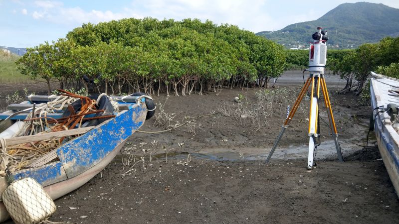
Mangrove Laser Scanning
Terrestrial Laser Scanner to do tree segmentation
Location: Waziwei Nature Reserve, Bali District, New Taipei City, Taiwan
Date:2019.08.27-2019.08.28
3D Modeling of Bent Mailbox in Taipei
Combine terrestrial laser scanner and close-range photogrammetry to construct the mailbox 3D model
Location: Longjiang Rd., Taipei, Taiwan
Date:2015.08.19
瀏覽數:
2026-07-21